Gorge Road, Cudlee Creek – They Did it the Hard Way
For anyone who has taken a drive up to the Adelaide Hills there is a good chance that sometime or another you’ve driven along the Gorge Road and ended up either at, or driving through the tiny town of Cudlee Creek. Now you’d know that Gorge Road is long, it’s windy, it is steep, and it has a lot of big rock cliffs.
Next time you travel that road, here’s something to keep in mind …. IT WAS MADE BY HAND. That’s right! Not a machine in sight! It is simply the work of lots of men with picks, shovels and trolleys! And below are the pics to prove it.
For those that aren’t familiar with the area, the dark line on the map above shows the whole of Gorge Road. And where the ‘Gorge Wildlife Park’ listed, that’s where the tiny town of Cudlee Creek is. There’s a few houses, a few farms, a church, a deli/post office and a wildlife park, so yes it’s a small country town.
Now for those of you who DO know the area, don’t you think that next time you travel along the road from Athelstone to Millbrook to Cudlee Creek (or viceversa), you’ll appreciate it just that little bit more thinking of the effort that actually went into making it?
I don’t have an exact date as to when these photos were taken, or for when the road was opened, and I have no doubt that various parts of the Gorge Road were built and opened at different times, but from what I have been able to find so far out the Cudlee Creek end of it was likely to have been constructed in the 1920s. If anyone has a more firm date, please let me know.

men at work constructing the Gorge Road at Cudlee Creek
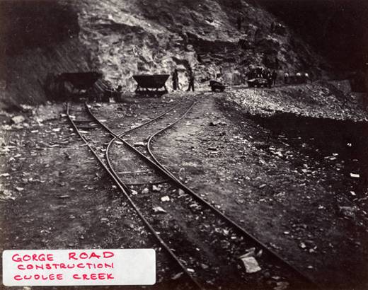
they used railway tracks and carts to haul away the rubble
5 Responses to “Gorge Road, Cudlee Creek – They Did it the Hard Way”
Leave a Reply


Aye, I knew about this. It’s pretty amazing. It’s a similar story of the Great Ocean Road – I think they used ex-soldiers or the like, and many a man was killed.
And to think we take these roads for granted now.
Wonderful photos and great info Alona… thanks. It’s an area which is very familiar, from childhood, I wrote a post some time back about being trapped in the Caravan Park there during one really horrific Bush Fire in the 1950’s.
Although a city girl, it’s a road we travelled on regularly during our regular “Sunday Drives” with mum and dad. I have strong memories of peering through the car window at the river on one side and, on the return trip, the hewed cliff face on the other. The colours of the rocks danced before my eyes and were mesmerising.
Thanks for taking me for a trip back down “memory lane” and especially the photos of the men who made those wonderful Sunday drives a possibility 🙂
Thanks for the pictures. But, I have wondered for years about the other road what has been cut in to the hill on the other side of the Torrens. It is higher up, starts just below Cudlee Ck & finishes at top of Kangaroo Ck.
Who built it & why?
Can anyone help me with info?
Thanks
Thanks for the info. Towards the Athelston end is a small tunnel, does anyone know what that is for? As a joke, when I was a kid I was told a lion lived in there and if we didn’t behave we would be put in there. Also I think the original road followed the river further but was the diverted when the dam was built.
The section along the Kangaroo Creek dam was built in the 1960’s prior to the building of the dam. My grandfather documented this construction in pictures and you can access them at the state library (Herman Greening Collection).